Surveying and Levelling
CE3351 3rd Semester Civil Dept 2021 Regulation

2021 regulation - 2nd year, 3rd semester paper for Civil Department. Subject Code: CE3351, Subject Name: Surveying and Levelling, Batch: 2021, 2022, 2023, 2024. Institute: Anna University Affiliated Engineering College, TamilNadu. This page has Surveying and Levelling, notes, semester question paper pdf download, important questions, lecture notes.
PDF Download Links
- (CE3351 2021 Regulation) Surveying and Levelling: Semester Question Paper 2023 Nov Dec
- (CE3351 2021 Regulation) Surveying and Levelling: Semester Question Paper 2023 April May
- (CE3351 2021 Regulation) Surveying and Levelling: Semester Question Paper 2022 Nov Dec
- (CE8351 2017 Regulation) Surveying: Semester Question Paper 2020 Nov Dec
- (CE8351 2017 Regulation) Surveying: Semester Question Paper 2019 Nov Dec
- (CE8351 2017 Regulation) Surveying: Semester Question Paper 2019 April May
- (CE8351 2017 Regulation) Surveying: Semester Question Paper 2018 Nov Dec
Surveying and Levelling
Notes and Question Answer of Unit I: Fundamentals Of Conventional Surveying will Uploaded shortly...
Notes and Question Answer of Unit II: Levelling will Uploaded shortly...
Notes and Question Answer of Unit III: Theodolite Surveying will Uploaded shortly...
Notes and Question Answer of Unit IV: Control Surveying And Adjustment will Uploaded shortly...
Notes and Question Answer of Unit V: Modern Surveying will Uploaded shortly...
PDF Download Links
- (CE3351 2021 Regulation) Surveying and Levelling: Semester Question Paper 2023 Nov Dec
- (CE3351 2021 Regulation) Surveying and Levelling: Semester Question Paper 2023 April May
- (CE3351 2021 Regulation) Surveying and Levelling: Semester Question Paper 2022 Nov Dec
- (CE8351 2017 Regulation) Surveying: Semester Question Paper 2020 Nov Dec
- (CE8351 2017 Regulation) Surveying: Semester Question Paper 2019 Nov Dec
- (CE8351 2017 Regulation) Surveying: Semester Question Paper 2019 April May
- (CE8351 2017 Regulation) Surveying: Semester Question Paper 2018 Nov Dec
Surveying and Levelling
Unit I: Fundamentals Of Conventional Surveying
Notes and Question Answer of Unit I: Fundamentals Of Conventional Surveying will Uploaded shortly...
Unit II: Levelling
Notes and Question Answer of Unit II: Levelling will Uploaded shortly...
Unit III: Theodolite Surveying
Notes and Question Answer of Unit III: Theodolite Surveying will Uploaded shortly...
Unit IV: Control Surveying And Adjustment
Notes and Question Answer of Unit IV: Control Surveying And Adjustment will Uploaded shortly...
Unit V: Modern Surveying
Notes and Question Answer of Unit V: Modern Surveying will Uploaded shortly...
PDF Download Links
- (CE3351 2021 Regulation) Surveying and Levelling: Semester Question Paper 2023 Nov Dec
- (CE3351 2021 Regulation) Surveying and Levelling: Semester Question Paper 2023 April May
- (CE3351 2021 Regulation) Surveying and Levelling: Semester Question Paper 2022 Nov Dec
- (CE8351 2017 Regulation) Surveying: Semester Question Paper 2020 Nov Dec
- (CE8351 2017 Regulation) Surveying: Semester Question Paper 2019 Nov Dec
- (CE8351 2017 Regulation) Surveying: Semester Question Paper 2019 April May
- (CE8351 2017 Regulation) Surveying: Semester Question Paper 2018 Nov Dec
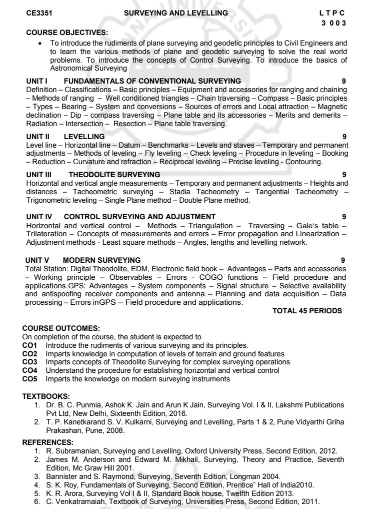
CE3351
SURVEYING AND LEVELLING
COURSE OBJECTIVES:
• To introduce the rudiments of plane surveying and
geodetic principles to Civil Engineers and to learn the various methods of
plane and geodetic surveying to solve the real world problems. To introduce the
concepts of Control Surveying. To introduce the basics of Astronomical
Surveying
UNIT I
FUNDAMENTALS OF CONVENTIONAL SURVEYING
Definition - Classifications - Basic principles -
Equipment and accessories for ranging and chaining - Methods of ranging - Well
conditioned triangles - Chain traversing - Compass - Basic principles - Types -
Bearing - System and conversions - Sources of errors and Local attraction -
Magnetic declination - Dip - compass traversing - Plane table and its
accessories - Merits and demerits - Radiation - Intersection - Resection -
Plane table traversing.
UNIT II
LEVELLING
Level line - Horizontal line - Datum - Benchmarks -
Levels and staves - Temporary and permanent adjustments - Methods of leveling -
Fly leveling - Check leveling - Procedure in leveling - Booking - Reduction -
Curvature and refraction - Reciprocal leveling - Precise leveling - Contouring.
UNIT III
THEODOLITE SURVEYING
Horizontal and vertical angle measurements -
Temporary and permanent adjustments - Heights and distances - Tacheometric
surveying - Stadia Tacheometry - Tangential Tacheometry - Trigonometric
leveling - Single Plane method - Double Plane method.
UNIT IV
CONTROL SURVEYING AND ADJUSTMENT
Horizontal and vertical control - Methods -
Triangulation - Traversing - Gale's table - Trilateration - Concepts of
measurements and errors - Error propagation and Linearization Adjustment
methods - Least square methods - Angles, lengths and levelling network.
UNIT V
MODERN SURVEYING
Total Station: Digital Theodolite, EDM, Electronic
field book- Advantages - Parts and accessories - Working principle -
Observables - Errors - COGO functions Field procedure and applications.GPS:
Advantages - System components - Signal structure - Selective availability and
antispoofing receiver components and antenna - Planning and data acquisition -
Data processing Errors in GPS - Field procedure and applications.
TOTAL
45 PERIODS
COURSE OUTCOMES:
On completion of the course, the student is expected
to
CO1
Introduce the rudiments of various surveying and its principles.
CO2
Imparts knowledge in computation of levels of terrain and ground features
CO3
Imparts concepts of Theodolite Surveying for complex surveying operations
CO4
Understand the procedure for establishing horizontal and vertical control
CO5
Imparts the knowledge on modern surveying instruments
TEXTBOOKS:
1. Dr. B. C. Punmia, Ashok K. Jain and Arun K Jain,
Surveying Vol. I & II, Lakshmi Publications Pvt Ltd, New Delhi, Sixteenth
Edition, 2016.
2. T. P. Kanetkarand S. V. Kulkarni, Surveying and
Levelling, Parts 1 & 2, Pune Vidyarthi Griha Prakashan, Pune, 2008.
REFERENCES:
1. R. Subramanian, Surveying and Levelling, Oxford
University Press, Second Edition, 2012.
2. James M. Anderson and Edward M. Mikhail,
Surveying, Theory and Practice, Seventh Edition, Mc Graw Hill 2001.
3. Bannister and S. Raymond, Surveying, Seventh
Edition, Longman 2004.
4. S. K. Roy, Fundamentals of Surveying, Second
Edition, Prentice Hall of India2010.
5. K. R. Arora, Surveying Vol I & II, Standard
Book house, Twelfth Edition 2013.
6. C. Venkatramaiah, Textbook of Surveying,
Universities Press, Second Edition, 2011.
Surveying and Levelling: Unit I: Fundamentals Of Conventional Surveying,,Surveying and Levelling: Unit II: Levelling,,Surveying and Levelling: Unit III: Theodolite Surveying,, Surveying and Levelling: Unit IV: Control Surveying And Adjustment,, Surveying and Levelling: Unit V: Modern Surveying 3rd Semester Civil Dept 2021 Regulation : CE3351 3rd Semester Civil Dept 2021 Regulation Surveying and Levelling


